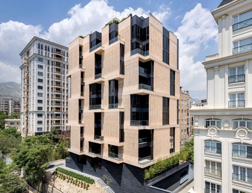
 عمارت ارثیه اثر علی موذن، درخشش هنرمندان ایران در عرصه های بینالمللی، برندهی جایزهی بینالمللی A'Design Award, 2025
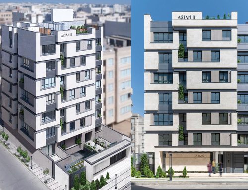
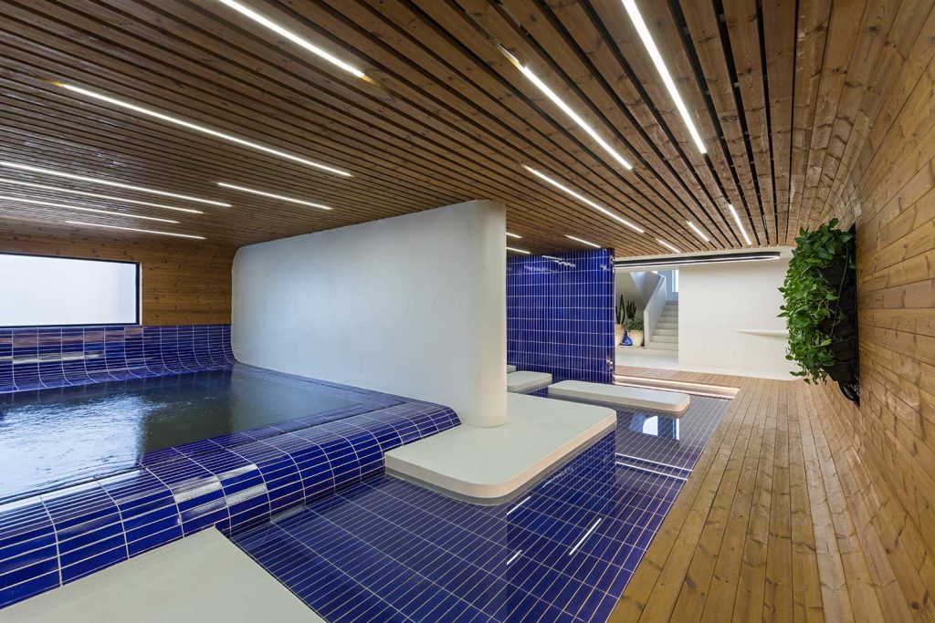 آپارتمان خط آبی اثر محمد امینی، فینالیست و راه یافته به مرحلهی دفاع از آثار دوازدهمین طراحی داخلی ایران بخش آپارتمانی، 1403
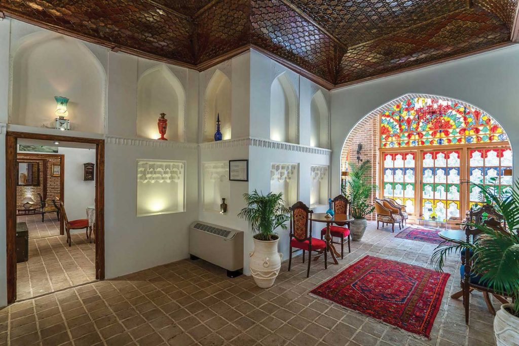
رستوران زاویه اثر احسان مالکی، یکتا آفرین
چهارمین شب معماران، فینالیست و راه یافته به مرحلهی دفاع از آثار هشتمین ساختمان سال ایران بخش عمومی، 1403
Zavieh Restaurant / Ehsan Maleki, Yekta Afarin


سایت پروژه قسمتی از مستر پلان شهرک چند منظوره آرام میباشد (که توسط این مشاور مطالعات فاز ۱ و ۲ آن در حال انجام است)
زمین انتخابی تنها قطعه مرتبط با بدنه خیابان اصلی (جاده فشم) میباشد. تنها بازمانده از ارتباط گسترده و سراسری در محدوده روستای زردبند که زمانی از دوراهی لواسان – فشم آغاز و تا انتهای محدوده فعلی روستای زردبند ادامه پیدا میکرد، آستانه ی کم ارز برای ورود به سایتی مملو از خاطره تاریخی. اولین اسناد ثبتی موجود سایت شهرک مربوط به سال ۱۳۱۳ است. اینجا آغاز ساخت باغی آباد (باغ فندق) برای خانواده بوده است که طی سالیان پیش رو مدام در امتداد تغییرات سیاسی و اقتصادی و اجتماعی پوست انداخته است. از زمین بایر در سال ۱۳۱۳ تا آبادانی قسمتی از آن به عنوان باغ فندق تا سال 1348 و سپس تخریب و آبادانی مدام از سال 1348 تا کنون، از مرگ مالک اولیه و حضور مدام آن در مقبره ی داخل سایت، تا ساخت و ساز توسط مالکین، فروش، مصادره و تصرف توسط نظام حاکمه و مردم و گسترش روستای زردبند در امتداد جاده و نهایتاً گسترش روستای زردبند در امتداد جاده (درون سایت و باغ فندق) و تخریب مدام درختان، بریدن قطعات زمین و ساخت و ساز مدام تا جایی که تنها زمین مانده ی مرتبط با خیابان قطعه ای ناموزون مشتمل به دو سند است. که همسایگان آن مسجد و پاسگاه سابق زردبند میباشد (شاید که تثبیت کننده تصرفات و فتوحات انسانی هستند).
سایت این پروژه، بخشی از مستر پلان 86000 مترمربع شهرک چندمنظوره آرام است (که در حال حاضر توسط این مشاور در حال طراحی می باشد). سایت شهرک از بر جاده واصله لواسان به فشم (محدوده زردبند) تا خط الراس کوه امتداد دارد (120 متر اختلاف ارتفاع). سرنوشت زمین از خرید آن در سال ۱۳۱۳ تا به امروز، متاثر از تغییرات مدام اجتماعی، سیاسی و جغرافیایی زمانه بوده است. خاکی که با تلاش و ممارست مالکین به باغ فندق و چنارستان تبدیل می شود، با نزدیکی به انقلاب، دچار سرنوشتی مبهم و غمانگیز می گردد. از ساخت و ساز درون آن توسط مالکین تا فروش و تقسیم قسمتهایی از آن در ادوار مختلف و نهایتا مصادره آن بر اساس ساختار حاکمه و پس از آن تصرفات متعدد توسط مردم و بومیان منطقه که بعدها زردبند نام گرفت. از زمین اصلی و ارتباط آن با خیابان و جاده تنها عرض ناچیز و کوچهای باقی مانده و دیگر آن قربانی شد. مرگ مالک اصلی و دفن آن در همان زمین (روبروی سایت پروژه رستوران و در مقبره خانوادگی) این تراژدی را غمناکتر کرد.
اکنون، بعد از دو نسل مالکین فعلی تصمیم به ساخت و ساماندهی گرفتند و افسوس ؛ که آنچه از دست رفته، تصویر زمین را همچون پارهای چهل تکه نشان میدهد. خاطراتی که می میرند تا بنایی جدید متولد گردد در جنوب شهرک، در حاشیه جاده اصلی، دو قطعه زمین به هم پیوسته قرار گرفته اند (تنها بازمانگان گذشته که اکنون زمان قربانی شدنشان است). حال خاطرات نسل دوم نیز قرار است از بین برود (زمین تنیس، مسیر ماشین رو و ساختمان سرایداری) این بار نیز تراژدی مطابق گذشته تکرار می شود، درختانی که قطع شدند و معدودی که ماندد.
قسمت اول: زمینی نامتوازن با ارتباط اندک به جاده اصلی که شامل دو سند تفکیکی از سال ۱۳۴۸ است. تودهای از درختان کهنسال که تنها بازماندگان قدیمی زمین و یادآور شکوه گذشته هستند.
قسمت دوم: سال ۱۳۶۵، قطع تعدادی چنار قدیمی و ویلایی که به بهانه مکانی برای گردهم اییهای خانواده ساخته شد.
قسمت سوم: سال ۱۳75، استخر، زمین والیبال، دسترسی ماشین به داخل سایت.
قسمت چهارم: سال ۱۳8۵، زمین تنیس و والیبال، هر یک به زندگی مدرن افزوده شد و زندگانی گذشته محو می شود؛ درست در مقابل چشمان مقبره.
قسمت پنجم: سال ۱۳9۵، تیغ برنده اداره ثبت در تفکیک زمین بر جان استخر قدیمی می افتد که به نظر تنها مانا همچنان همان مقبره است.
قسمت ششم: سال ۱۳9۵، طرح هادی روستایی که الزام به ساخت در محدودهای پر از درخت و توصیه به قطع آنها را داشت (که آنها نیز به سرنوشت دوستان مقتول خود دچار شدند).
قسمت هفتم: سال ۱۳96، جانمایی اولیه بنای رستوارن توسط نمایندگان دهیاری و تکرار همان تراژدی کشتار درختان.
قسمت هشتم: سال ۱۳9۶، اصلاحیه حریم جاده که آنچه مانده را بود نیز محو کرد.
قسمت نهم: از آن باغ انبوه تنها شش اصله درخت باقی مانده، غریبانه نظارهگر سرنوشت هستند.
مبانی نظری طرح مبتنی بر این گذشته غمانگیز است، خود حرف از تخریب می زند، تخریبی مدام! در تضاد با محیط است؛ در تضاد با طبیعت. آنچه تولید میشود، نافی امر معماری و ضد آن است. تنها نگاه کمسوی سایت به مقبره مانده است. اکنون، تخریب همچنان ادامه دارد با اخراج شش چنار (تنها بازماندگان کشتار) به واسطه تصمیم معمارانه! بنا مبتنی بر گذشته تغییر یافته، بیهویت شده بیانگیزه. سکوت میکند و همصدا با کاربران جدید آوازی تهی میخواند، اما نگاه خیره آن همچنان بر مرگ متمرکز است و گام بر می دارد…
این آیرونی معماری است.
چهارمین شب معماران ایران، 1403
_______________________________________
نام پروژه: رستوران زاویه
دفتر طراحی: مهندسین مشاور آتی زیست
معماران اصلی: احسان مالکی، یکتا آفرین
همکاران طراحی: حسن عابدی، لیلی بهمن بیجاری، پویا سنجری، عاطفه لهراسبی، نازگل محمدزاده
تاسیسات: علیرضا شادبخش
سازه: دکتر حمیدرضا احمدیان
اجرا توسط: فرهنگ فروزش، احسان گوهری نیک
نقشه های اجرایی معماری: حسن عابدی
عکاس: محمدحسن اتفاق
کارفرما: آقای بهنام حشمتی و شرکا
آدرس پروژه: تهران، میدان لشگرک، کیلومتر 1 جاده فشم
کاربری بنا با ذکر جزئیات: عمومی تجاری – مجموعه کافه و رستوران
نوع تأسیسات: موتورخانه مرکزی + هواساز
نوع سازه: اسکلت فلزی
مساحت و زیر بنا: 1447 متر مربع
سال شروع و خاتمه اجرا: 1403-1398

Projct Name: Zavieh Restaurant
Office: Atizist Consulting Engineers
Main Architect: Ehsan Maleki, Yekta Afarin
Collaborators: Hasan Abedi, Leili Bahman Bijari, Pouya Sanjari, Atefeh Lohrasbi – Nazgol Mohamadzadeh
Facilities: Alireza Shadbakhsh
Structure: Hamidreza Ahmadian
Execution Of Building: Farhang Forouzesh, Ehsan Gohari Nik
Executive Plans: Hasan Abedi
Photo: Mohamad Hasan Etefagh
Client: Behnam Heshmati & Partners
Location: Lashgark Square, Zardband, Kilometer 1, Fasham Road, Tehran
Mechanical Structure: Central engine room + air conditioner
Area: 1447 m2
Year: 2019-2024
The project site is part of the master plan for the multi-functional Aram Township, currently under Phase 1 and 2 studies by this consultancy. The selected plot is the only parcel directly connected to the main street (Fasham Road), serving as the last remnant of the extensive, interconnected fabric of Zardband village. This network once stretched from the Lavasan-Fasham junction to the farthest reaches of the current Zardband boundary, standing as a modest threshold to a site brimming with historical memory.
The earliest registered documents for the township site date back to 1934 (1313 in the solar calendar). This marks the beginning of the transformation of barren land into a thriving garden (Hazelnut Garden) intended for family use. Over the ensuing decades, the site underwent constant changes, shaped by political, economic, and social developments.
From barren land in 1934 to its partial flourishing as the Hazelnut Garden by 1969, the site experienced cycles of construction and destruction. These transitions include the passing of its original owner, whose tomb remains within the site, alongside successive phases of construction by various owners, land sales, confiscations, and eventual occupations by ruling authorities and local communities. This evolution paralleled the expansion of Zardband village along the road, progressively encroaching upon the site.
The continuous cutting of trees, subdivision of land, and unrelenting construction have reduced the original site to an irregular, fragmented plot with only two surviving deeds. Its immediate neighbors now include the mosque and the former Zardband police station, structures that perhaps symbolize the enduring human imprint of conquest and territorial assertion.
The location for this project is part of an 86,000 square meter master-planned multi-purpose township, currently being designed by this consultant. The site stretches from the road connecting Lavasan to Fasham (Zardband area) up to the mountain ridge, (with a 120-meter elevation difference.)
The fate of the land, since its purchase in 1934 (picture 1), has been shaped by the social changes, political, and geographical conditions of the times.
The land, which was once cultivated into a hazelnut orchard and plane tree grove with great effort and dedication (picture 2). Faced a tumultuous fate with the approach of the revolution.
The land experienced various stages, from construction by the owners (picture 3) to its sale and division into parts over different periods (picture 4), and eventually, its confiscation. This was followed by numerous occupations by locals, leading to the area being known as Zardband.
The original land and its connection to the street and road have been reduced to a narrow strip and an alley, rendering the land a victim of these changes. The death of the original owner and his burial on the same land (opposite the restaurant project site in the family mausoleum) further intensified this tragedy. (picture 5) Now, after two generations, the current owners have decided to develop and organize the land, only to lament that what has been lost presents the land as a fragmented patchwork.
Chapter One: An uneven plot with low connection to the main road, which includes two separation documents from 1986 and a villa building in the south of it. It also features a collection of old trees, the only remnants of the land’s past splendor.
Chapter Two: In 1986, several old plane trees were cut down, and a villa was constructed as a gathering place for the family.
Chapter three : In 1996 ,An addition of a swimming pool, volleyball court, vehicle access
Chapter four : In 2006 ,tennis court represented a shift towards modern living, erasing the past Right in front of the grave!
Chapter five: In 2006 , The registry office insisted on demolishing the old pool to separate the land, and it seems that the only stable element in this site is the grave itself.
Chapter six: In 2006 , Hadi roosataei order which was required to build in an area full of trees and advised to cut them down (which also suffered the fate of their murdered friends).
Chapter seven: In 2007 , Dehyari order for the restaurant was designed by Representation Dehyari, repeating the tree-cutting tragedy.
Chapter eight: In 2007 , The Road Administration’s Road construction that removed part of the land
From the once-lush garden, only four trees remain, silently observing their fate.
Chapter eight: In 2007 , ONLY SIX TREES LEFT.
The theoretical foundation of the design is based on this tragic past, symbolizing destruction and opposition to the environment, history, the observer, and an angry nature.
What is produced contradicts architectural principles and is opposed to them
This creation is a product of continuous destruction up to the present moment. The only faint connection of the site remains with the mausoleum, and the destruction persists with the removal of six plane trees (the last survivors of the massacre) due to architectural decisions! The structure, based on a transformed, identity-less past, remains silent and, along with new users, sings a hollow song but continues to focus on death.
This is architectural irony.


مدارک فنی


مطالب مرتبط